Thursday 11 July 2013

It's Getting Blending by the Sea

There are new tiles!

They still have "Town Centre" and "Leigh-on-Sea" (a made-up place name if ever I saw one).

And the motorway colours are wrong. It's a well established principle of UK mapping that Motorways are blue. I was glad when Google Maps decided to accept this. Now they've changed their mind... Presumably so that they only have one stylesheet for the entire world? At least with motorways it's obvious what's happened. With the Primary Route Network, A-roads and B-roads I have no idea. Is there a key? Hahaha.

But the sea's got a nice gradient to it now, so it's not all bad.

Sunday 7 July 2013

"Town Centre"

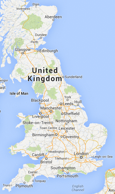
Do you remember last post, when I was complaining about Google Maps deciding that Tilehurst and Headington were more important places to mark on a map of the UK than Oxford and Reading?

The good news is that although it still does this, it is now no longer the stupidest thing on the map!

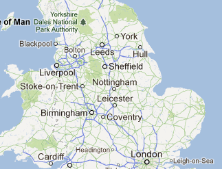
You see that thing just between Stoke and Birmingham, called "Town Centre".

That's the most stupid thing on the map. By far. Not just because it's Telford (although I'd question the wisdom of putting Telford on the map), but because it just says "Town Centre". No context. And then when you zoom in it just disappears.

The thing is, this used to work, back when Google Maps launched. It's not that difficult. OpenStreetMap do a much better job. If I look at the equivalent zoom level there I see it has a slightly eccentric choice of what settlements to show (it picks those that are ceremonially cities, so you get Ely but no Reading, for example), but at least that's consistent and defensible. Nobody chose Tilehurst, or "Town Centre". They just didn't check the output of the algorithm before they went live. People use Google Maps for directions. People rely on it. Is it really safe?

Thursday 28 March 2013

University of Headington

Lots of new features since we posted last. The most visible is perhaps the layouts of malls, as demonstrated here with the One New Change development, grimly ironically situated next to St Paul's.

It looks quite spiffy, doesn't it? It's good that they have got to this level of fine detail because it means they have finally sorted out more basic levels of general data quality issues?

What's that you say?

You're fairly sure that Headington and Leigh-on-Sea shouldn't be on this map; and wouldn't Oxford and Southend would be more worthy of captioning at this zoom level?

And you're not sure about whether the Yorkshire Dales should be labelled at all, but if they do it probably shouldn't be as the "Yorkshire Dales National Park Authority" but the "Yorkshire Dales", for crying out loud does anyone do any QA on these at all before pushing them live this is seriously going to damage Google's fast-diminishing reputation if it keeps up? Sorry, you seem to have got into a bit of a stream of a consciousness babble there. But I get that you're unhappy. Tell you what, why don't you wait until the next set of tile revisions, in a couple of months. I'm sure it will be all fixed then!